Please help to oppose Mississippi River Bridge Option E-11-IV, which would cut through the middle of the woods in Plaquemine Point, including old-growth cypress forest. This website includes information Plaquemine Point residents and landowners have provided to the DOTD and FHWA in official public comment over the last 2 1/2 years.
The last meeting was on . The recordings can be found here .
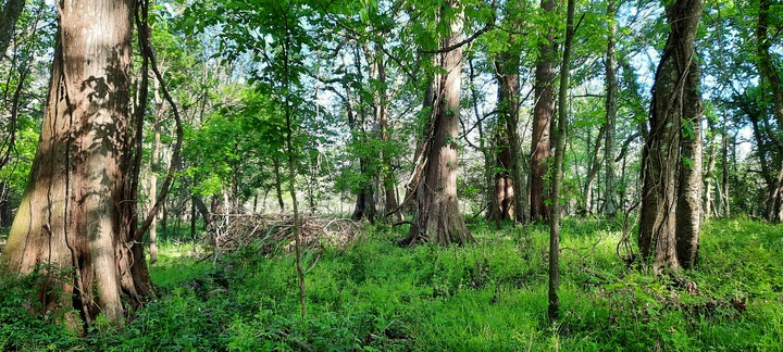
Plaquemine Point Faces Imminent Threat
The area known as Plaquemine Point is located inside a bend on the east side of the Mississippi River in Sunshine, Louisiana and is a significant cultural landscape. Plaquemine Point is an oblong site approximately ten miles long and one mile wide located in Iberville Parish. Along the river road, which makes a 180 degree turn on the far end, there are woods behind all the houses, making the woods behind our homes one continuous habitat for wildlife, protected in a sort of refuge in this bottomland hardwood and cypress forest ecosystem.
One of three final bridge alternatives is Option E-11-IV, which has a 4-lane divided approach highway that cuts through Plaquemine Point, bisecting the community and bisecting the woods in the center of the point. The land that will be purchased through expropriation / eminent domain will be 600-ft wide along the path of the approach highway.
We are expressing the desire to save the Plaquemine Point woods ecosystem — trees, plants , and animals — from destruction. Animals on this land already have a limited amount of woods in which to live and roam. The animals cannot just move to another patch of woods somewhere else after the bridge is built, because they are isolated, cut-off on three sides by the river and on one side by industry.
Our Plaquemine Point "back-yard" forest in Sunshine is of cultural significance. We are the descendants of the Acadian exiles placed here by the Spanish Government in 1767 as well as those who sought out this peaceful place for their families to have a country life close to nature. The people in this community have been hunting on the backs of their properties for centuries. Several families have not taken timber during the last hundred years to keep the woods a secure habitat for wildlife.
In the middle of Plaquemine Point lies the 60-acre A.E. LeBlanc Natural Area and Old-Growth Cypress Forest. It has been recognized by the following seven organizations due to its rarity and unique features:
- Endangered by the Louisiana Trust for Historic Preservation (LTHP)
- Natural Area by the Louisiana Department of Wildlife and Fisheries (LDWF) Wildlife Diversity Program
- Cypress Legacy Forest by the Louisiana Purchase Cypress Legacy (LPCL)
- Old-Growth Forest by the Old-Growth Forest Network (OGFN) (see also: A Threatened Louisiana Icon
- Regenerating Cypress Forest by Louisiana State University Environmental Sciences Department Regenerating Cypress Forest Research Project
- Old-Growth Cypress Forest located within the Plaquemine Point Cultural Landscape by The Cultural Landscape Foundation (TCLF)
- Forest Flora and Biota Research Grant Recipient from the Louisiana Native Plant Society (LNPS)
Bridge option E-11-IV, in addition to destroying the A. E. LeBlanc Forest Natural Area and other old growth forest, will destroy another 125 acres of precious forested land owned by approximately 20 other land owners in Plaquemine Point. Of the 32 bridge options studied by Louisiana DOTD, many viable alternatives that would not cut down forest could have been chosen for the final three options, and should be reconsidered.
The Louisiana State Tree is the Bald Cypress, and the trees in this Natural Area were here before Louisiana became a state. The conservation of Louisiana’s forested areas, such as this old-growth cypress forest is critical. Natural lands and forested wetlands are part of the state’s cultural heritage, especially cypress forests. Preservation of old-growth forested lands, especially when done voluntarily by landowners, is one way to achieve a balance between development and smart land management in Louisiana.
The old cypress trees were standing when our Acadian ancestors settled in Sunshine and St. Gabriel in 1767 after being exiled by the British from their own land in Acadia (today’s Nova Scotia). The hunters who have traditionally hunted this land have been good managers of the animal population. If E-11-IV bridge option is chosen, it would be an end to this animal population and the generations-deep tradition of responsible hunting by the people in Plaquemine Point.
In 1779, only twelve years after their 1767 arrival in Plaquemine Point (known as Fort San Gabriel de Manchac at that time), our Acadian ancestors joined the Spanish General Bernardo de Galvez, who as Governor of Louisiana, helped the Americans fight the Revolutionary War against the British. He and his army passed on foot through Plaquemine Point in the historic fight against the British at nearby Fort Bute at Bayou Manchac. Fort San Gabriel was on the south bank of Bayou Manchac, opposite British Fort Bute at the international border between Spain and Britain. Fort San Gabriel was one of only 3 Spanish outposts on the Mississippi River above New Orleans (along with Pointe Coupee and Fort San Luis de Natchez) and was key to the protection of navigation on the Mississippi river to and from New Orleans. The rich cultural significance of this area should be investigated by anthropologists, not destroyed.